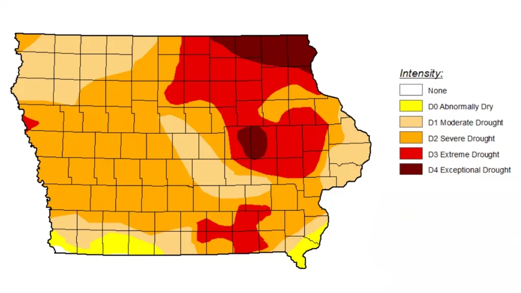
The latest U.S. Drought Monitor map released on Thursday shows worsening drought conditions in eastern Iowa. Officials have identified areas of Exceptional Drought (D4), the most severe category, for the first time since 2012. Although Tuesday brought significant rainfall to parts of the state, including here in the Carroll Broadcasting listening area, most of it occurred after the reporting deadline. As a result, the impact of this rain won’t be reflected until the Sept. 28 report. However, Tuesday’s rainfall, coupled with anticipated widespread rainfall over the weekend, is expected to alleviate conditions and limit further deterioration. Exceptional Drought now covers 4.9 percent of the state, marking the greatest extent since the inception of the U.S. Drought Monitor in 2000. Precipitation deficits in the driest areas are substantial, with some counties receiving less than 50 percent of normal summer rainfall, making this the driest summer on record in those regions. State Climatologist Dr. Justin Glisan says, “The current drought, which is approaching 170 consecutive weeks of at least D1-Moderate Drought conditions somewhere in the state, has been the longest in the U.S. Drought Monitor’s nearly 24 year period of record. Recent rainfall and short-term outlooks offer hope for improvement which would be reflected in decreasing precipitation deficits, soil moisture recharge, and rising streamflows. The fall months have the potential to provide significant amounts of moisture to the state as we head into the winter.” The September Water Summary Update is slate for release on Oct. 5, and a link to where that report will be posted is included with this story on our website.
_____

