


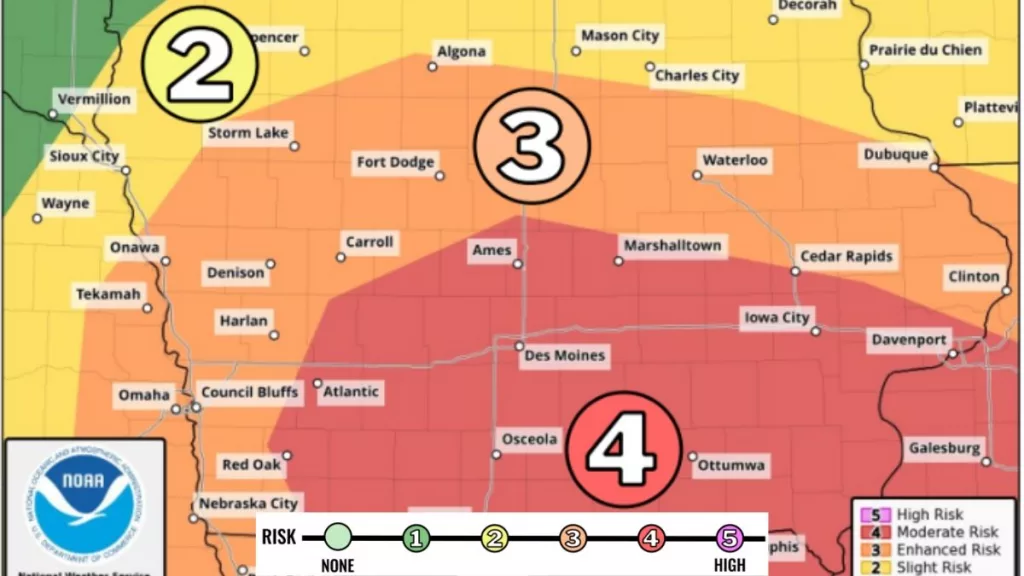
The first thunderstorm of the season is expected to bring severe weather to Iowa this (Friday) afternoon and evening, with damaging winds, possible tornadoes, and large hail in the forecast, according to the National Weather Service (NWS). The storms are forecasted to develop quickly between 4 p.m. and 10 p.m., moving at speeds of 50 to 60 mph. The greatest threat will be damaging winds, with gusts of up to 70 mph across central Iowa. Tornadoes, some potentially strong, and large hail are also possible, particularly in southeastern parts of the state. Even outside of thunderstorms, strong south-southeast winds could reach 50 mph over southern and eastern Iowa, leading to critical fire weather conditions. A Red Flag Watch has been upgraded to a Red Flag Warning, and residents are advised to avoid burning, as fires could quickly become uncontrollable. Most of the listening area is an “enhanced risk” category for severe weather Friday, while eastern Audubon County, all of Guthrie County, and southern Greene County are considered at “moderate risk.” A Wind Advisory is also in effect, with gusty conditions continuing into Saturday. Cooler temperatures and light-blowing snow are possible in northern Iowa. If severe weather occurs, ensure you have access to a battery-powered weather radio and stay tuned to your Carroll Broadcasting stations.